Contour Map Generator
Contour Maps and More Delivered Immediately
Protect yourself from hidden liabilities with contour maps and other assets that analyze your land’s natural features—enabling you to choose the right real estate, plan your property the smart way, and unlock long-term resilience.
Avoid Costly Property Mistakes. Plan Smarter With Contour Map Generator.
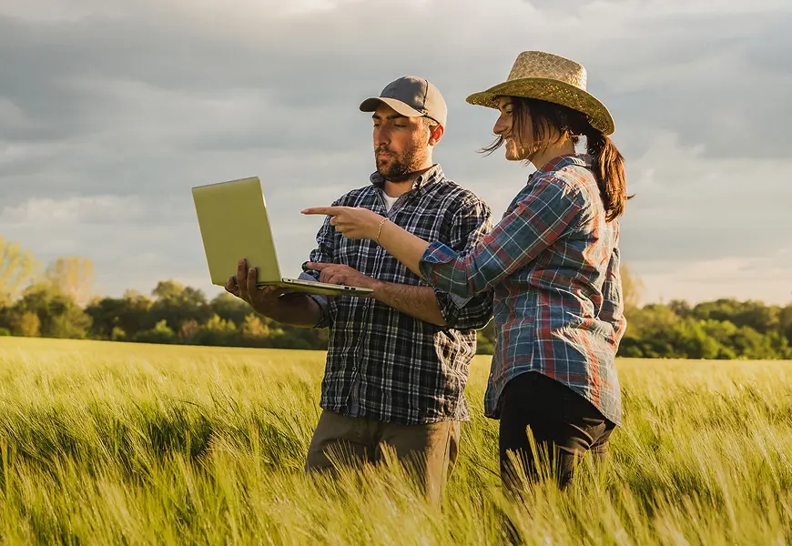
Buying land and building on it can be overwhelming. And hidden issues like flood risk, limited water access, or insufficient solar energy can derail your vision and drain your budget. Without the right data, property planning mistakes only become apparent long after the money’s spent—and traditional surveys can run tens of thousands of dollars.
Contour Map Generator is a quick, science-backed, and affordable solution that helps you spot and avoid critical planning risks. Just input a location, and our platform instantly delivers key land insights—so you can build a thriving, future-ready property.
Avoid Costly Property Mistakes. Plan Smarter With Contour Map Generator.
Buying land and building on it can be overwhelming. And hidden issues like flood risk, limited water access, or insufficient solar energy can derail your vision and drain your budget. Without the right data, property planning mistakes only become apparent long after the money’s spent—and traditional surveys can run tens of thousands of dollars.
Contour Map Generator is a free, quick and science-backed solution that helps you spot and avoid critical planning risks. Just input a location, and our platform instantly delivers key land insights—so you can build a thriving, future-ready property.
Build Your Maps, Your Way: From Free to Fully Loaded—You Decide
Building a resilient, self-sufficient home starts with understanding your land. Contour Map Generator outperforms traditional methods in cost, speed, and quality—using a whole-systems approach to deliver comprehensive, actionable insights in minutes, not months.
From managing stormwater and flood risk to planning your home, driveway, gardens, and solar panels, it simplifies complex decisions so you can design with confidence. Begin with our free Basic Contour Map, then add layers like Water, Sun, Biodiversity, Land, Climate, or a Property Sustainability Assessment—paying only for the data you need.
Step 1
Click “Get Started” to receive our free Basic Contour Map and to order add-ons: Water, Sun, Biodiversity, Land, Climate, or a Property Sustainability Assessment.
Step 2
Draw your property’s boundaries using our interactive map tool.

Step 3
Instant delivery! Most maps arrive within minutes. Higher-resolution requests are handled manually at an added cost.
Step 1
Understand your goals and vision
Step 2
Craft a proposal outlining how we work together
Step 3
Complete a remote property assessment using our proprietary data tools
Contour Map File Type and Resolution
- ✓ Google Earth Pro file (easy download instructions provided by email)
- ✓ One to three meters resolution in the US and UK. (More locations coming soon!)
- ✓ 30-meter standard resolution globally
- ✓ Manual high-resolution options available at an additional, quoted cost. Contact us for more information
Contour Map Generator Packages
Get started with our free Basic Contour Map and customize with powerful add-ons*! Our products are ideal for property owners looking to plan and build their resilient and sustainable homestead—as well as professionals involved in land design.
Basic Contour Map
Free
What's Included:
✓ Contours: Reveals shape and elevation, showing hills, valleys, and slopes
Water
Free
What's Included:
✓ Expanded Water Catchment: The larger scale watershed in which your property is located, including major rivers and tributary networks
- Understand how a property might be affected by upstream activities. For example: If the area in your greater water catchment is mainly deforested, there may be flash flooding in low areas during storms and droughts during warm periods; the opposite being true for forested areas
Sun
Free
What's Included:
✓ Solar Exposure Map: Total available shortwave radiation on the winter solstice and equinox
- Optimize solar energy production by identifying areas less affected by shadows and receive the highest amount of sunlight year-round
- Design gardens and food production in alignment with sunshine hours, as well as the most photosynthetically active radiation (PAR) energy available during the growth season
- Plan gardens and energy systems by understanding microclimates
- Determine which plant species are suitable for cultivation based on available energy
- Optimize comfort by planning structure placement based on desired sun exposure
Biodiversity
Free
What's Included:
✓ Biodiversity Report: Historical and current species tracking through the iNaturalist platform
- Protect endangered species by understanding which habitats to keep intact and nurture
- Plan for species that could adversely affect a property. For example: Fencing for deer
- Understand species that could be hunted, fished, or foraged for sustenance such as animals as well as plants, fruits, vegetables, and fungi
- Attract beneficial species such as pollinators using native perennials
- Plan plantings that support missing functional groups
Land
Free
What's Included:
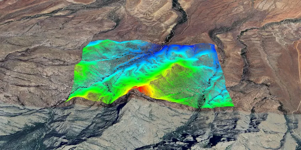
✓ Elevation: High and low points
- Plan water storage sites at the highest points and ponds at the lowest points
- Design systems where water flows downhill by gravity, powering irrigation, distributing water, and enabling passive energy use without the need for pumps
✓ Hillshade and Coloured Hillshade: Property map in virtual 3D
- Plan water storage sites at the highest points and ponds at the lowest points
- Design systems where water flows downhill by gravity, powering irrigation, distributing water, and enabling passive energy use without the need for pumps
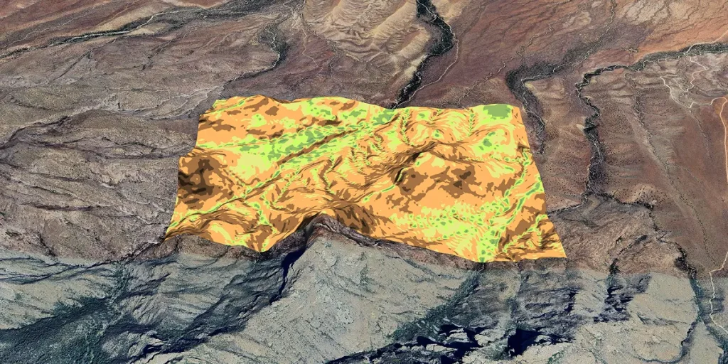
✓ Slope Angle and Parted Slope Angle: Flat or steep land
- Identify areas appropriate for construction, farming, or forestry
- Avoid steep, erosion-prone slopes
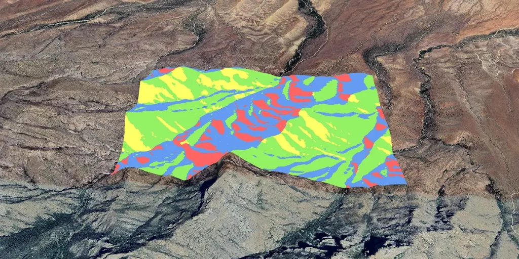
✓ Slope Direction: Flow of water and air, and diurnal warm or cold microclimates
- Diagnose water issues such as flooding and identify water harvesting opportunities
✓ Aspect and Parted Aspect:: North, East, West and/or South facing slopes as well as sunlight exposure, precipitation, temperature variations, microclimate, and soil quality
- Understand microclimate conditions for growing food
- Identify areas that are more or less prone to fire
Climate
Free
What's Includedd:
✓ Location-Specific Climate Charts: Shows temperatures, precipitations, frosts, insolations, weather trends, yearly and seasonal wind roses
- Ensure property design is relevant to prevailing climate conditions
- Schedule gardening activities in alignment with when the growing season starts and ends
- Design roof or landscape rainwater harvesting systems using precipitations data
- Plan solar panels using insolation data (ideally in conjunction with the Sun package)
- Determine edible plant species using minimum, average, and maximum temperatures
- Understand flood risk through daily precipitation data
- Design windbreak solutions in alignment with wind data
- Identify fire risk by understanding dominant wind direction during fire season
Contour Map Generator Packages
Get started with our free Basic Contour Map and customize with powerful add-ons*! Our products are ideal for property owners looking to plan and build their resilient and sustainable homestead—as well as professionals involved in land design.
Basic Contour Map
Free
What's Included:
✓ Contours: Reveals shape and elevation, showing hills, valleys, and slopes
Water
Free
What's Included:
✓ Expanded Water Catchment: The larger scale watershed in which your property is located, including major rivers and tributary networks
- Understand how a property might be affected by upstream activities. For example: If the area in your greater water catchment is mainly deforested, there may be flash flooding in low areas during storms and droughts during warm periods; the opposite being true for forested areas
Sun
Free
What's Included:
✓ Solar Exposure Map: Total available shortwave radiation on the winter solstice and equinox
- Optimize solar energy production by identifying areas less affected by shadows and receive the highest amount of sunlight year-round
- Design gardens and food production in alignment with sunshine hours, as well as the most photosynthetically active radiation (PAR) energy available during the growth season
- Plan gardens and energy systems by understanding microclimates
- Determine which plant species are suitable for cultivation based on available energy
- Optimize comfort by planning structure placement based on desired sun exposure
Biodiversity
Free
What's Included:
✓ Biodiversity Report: Historical and current species tracking through the iNaturalist platform
- Protect endangered species by understanding which habitats to keep intact and nurture
- Plan for species that could adversely affect a property. For example: Fencing for deer
- Understand species that could be hunted, fished, or foraged for sustenance such as animals as well as plants, fruits, vegetables, and fungi
- Attract beneficial species such as pollinators using native perennials
- Plan plantings that support missing functional groups
Land
Free
What's Included:
✓ Elevation: High and low points
- Plan water storage sites at the highest points and ponds at the lowest points
- Design systems where water flows downhill by gravity, powering irrigation, distributing water, and enabling passive energy use without the need for pumps
✓ Hillshade and Coloured Hillshade: Property map in virtual 3D
- Plan water storage sites at the highest points and ponds at the lowest points
- Design systems where water flows downhill by gravity, powering irrigation, distributing water, and enabling passive energy use without the need for pumps
✓ Slope Angle and Parted Slope Angle: Flat or steep land
- Identify areas appropriate for construction, farming, or forestry
- Avoid steep, erosion-prone slopes
✓ Slope Direction: Flow of water and air, and diurnal warm or cold microclimates
- Diagnose water issues such as flooding and identify water harvesting opportunities
✓ Aspect and Parted Aspect:: North, East, West and/or South facing slopes as well as sunlight exposure, precipitation, temperature variations, microclimate, and soil quality
- Understand microclimate conditions for growing food
- Identify areas that are more or less prone to fire
Climate
Free
What's Included:
✓ Location-Specific Climate Charts: Shows temperatures, precipitations, frosts, insolations, weather trends, yearly and seasonal wind roses
- Ensure property design is relevant to prevailing climate conditions
- Schedule gardening activities in alignment with when the growing season starts and ends
- Design roof or landscape rainwater harvesting systems using precipitations data
- Plan solar panels using insolation data (ideally in conjunction with the Sun package)
- Determine edible plant species using minimum, average, and maximum temperatures
- Understand flood risk through daily precipitation data
- Design windbreak solutions in alignment with wind data
- Identify fire risk by understanding dominant wind direction during fire season
Get Hands-on Expert Guidance for Your Property Design
Your property is unique. Its design should be too.
While Contour Map Generator gives you foundational insights, sometimes you need a partner who can translate topographical, water, sun, biodiversity, climate, and land health data into a full site strategy and roadmap.
That’s where our Regenerative Property Design team comes in.
Whether you’re planning an estate, homestead, farm, or retreat, 5th World helps you design with the land—not against it.
Property Sustainability Assessment—From $3,000
The Property Sustainability Assessment provides the full data suite: Basic Contour Map, Water, Sun, Biodiversity, Land, and Climate, as well as a Land Health Score. Plus, you get exclusive access to a bespoke, expert interpretation of this data in a clear report detailing your property’s constraints and opportunities.
Why Clients Love Contour Map Generator
ContourMapGenerator has been a game-changer for my consulting work. Instead of spending months developing advanced ArcGIS skills, I’ve been able to rely on their expertise to seamlessly integrate high-end GIS outputs into my reports and design work. The result is a clear step-change in quality, clarity and professionalism that my clients immediately notice.
What truly sets ContourMapGenerator apart is the value they deliver. For a relatively small investment, you receive a powerful, polished GIS package that dramatically elevates your work. An exceptional return on results. The team is highly responsive, supportive and genuinely invested in helping you succeed. They don’t just produce maps; they strengthen your consulting offer and help you stand out.
This is not a one-off service but a long-term partnership I rely on, and I wouldn’t consider working without their support. I strongly recommend ContourMapGenerator to any consultant or designer looking to upgrade their game with premium GIS outputs, without needing to become a specialist.
André Jordão
São Miguel Island, Portugal
A lot of what [5th World’s property assessment] told us about the land we’d sensed, but it was really helpful to have it validated—it gives a lot more certainty to the execution of our projects, because there’s more confirmed depth to our understanding.
Nicole
Alberta
My biggest gain out of 5th World’s Contour Map Generator was showing me how I could work with the land to make it fit my design preferences.
Naheed Henderson
Pemberton, British Columbia
5th World’s land assessment] taught me a couple of things I didn’t know about the property that surprised me and were quite interesting, particularly around where the water naturally drains. It also reaffirmed a lot of things that I kind of suspected and gave a really nice visual representation.
Gil Greenberg
East of Hanover, Ontario
Case Study
A City Slicker’s Regenerative Hobby Farm
After moving from the city to a 160-acre riverfront property, Chad Leibel hired 5th World to help him perfect his hobby farm. He wanted to optimize his property’s ability to produce self-sufficient supplies of food, water, and energy—while enhancing climate resilience. 5th World’s land assessment proved to be a valuable tool in service of these goals.
Case Study
Contour Map Generator Helped This Homesteader Plan Her Dream Orchard
Naheed Henderson wanted to explore new ways to produce food. Specifically, she pictured planting an orchard along the path her children take to school, creating a beautiful, shaded landscape where they could walk and enjoy harvesting fruit together. So, she ran a land assessment with 5th World to inform her planning.
Case Study
Avoid Costly Property Mistakes. Plan Smarter With Contour Map Generator.
Naheed Henderson wanted to explore new ways to produce food. Specifically, she pictured planting an orchard along the path her children take to school, creating a beautiful, shaded landscape where they could walk and enjoy harvesting fruit together. So, she ran a land assessment with 5th World to inform her planning.
Discover the transformative power of Contour Map Generator. Designed to unlock your land’s regenerative and resilient potential, our maps and reports display and analyze vital metrics so you can make informed decisions about your property. Let’s work together to create a data-driven plan that helps you achieve your goals.

Rob Avis
Chief Engineering Officer, 5th World
Contact Us
*5thworld.com needs the contact information you provide to us to contact you about our products and services. You may unsubscribe from these communications at any time. For information on how to unsubscribe, as well as our privacy practices and commitment to protecting your privacy, please review our Privacy Policy.